 In a recent article published in Palaeo 3, a team led by Professor Nizar Abu-Jaber in collaboration with researchers from the German Protestant Institute for Archaeology in Amman and Yarmouk University describe the discovery of Lake Elji. The 13 km length, 2.5 km width and 50 m deep lake lasted from about 70 thousand until about 8 thousand years ago. The city of Petra lies in the center of the former lake.
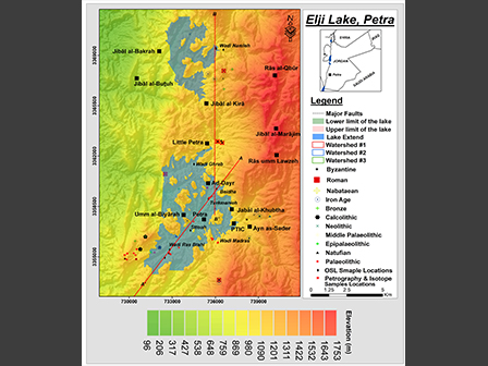
Dr. Abu-Jaber, head of the Center for the Study of Natural and Cultural Heritage (CSNACH) at GJU, explained that the area was a closed basin then. This meant that the waters entering into the basin at that time, which was significantly more humid, did not drain out until it spilled over a low point in the south of the basin. Evidence of a waterfall was discovered over beyond this spill point. All around the margin of the basin, evidence of lake deposit carbonates are found at the 1060m contour line, which is the same level as the spill point. A second ring of deposits is found at the 960 contour line, indicating a lower level of water towards the end of the life of the lake as the climate began to change. Finally, about 8000 years ago, earthquakes and tectonic movement changed the shape of the basin and caused water to start draining towards the west rather than towards the south. This led to the erosion of the sediments that had accumulated in the basin and allowed for the Nabateans to inhabit the area and carve their magnificent city.
Dr. Mohammad Alqudah from Yarmouk University elaborated on the carbonates that are found at the lake margins, explaining that they contain an abundance of freshwater fossils and algae that indicate long-standing water levels at these elevations. He added that there are abundant depositional and morphological evidences that the basin was filled with a freshwater lake for a long time.
Dr. Sahar Al Khasawneh described how the sediments in the basin were dated using Optically Stimulated Luminescence (OSL). This technique was used on the clastic sediments in the center of the lake to determine the last time the sediments were exposed to sunlight. Her measurements confirm the ages were indeed from the Late Pleistocene and Early Holocene. Dr. Abdullah al Rawabdeh, also from Yarmouk University, described the latest geomatic techniques that were used to determine the lake level and its spatial extent. This included the use of Unmanned Areal Vehicles (UAV’s) as well as modern GPS and satellite photographs as well as digital elevation models.
Dr. Catreena Hamarneh of the German Protestant Institute for Archaeology in Amman explained that mapping out the extent of early human settlements up to the Nabatean period shows clearly that people living in the area were responding to the presence of the lake, and were restricted to its margins up until the Neolithic period. After the breach of the lake and the changing of the hydrological pattern in the area, the lake sediments still filled the basin for a long time, allowing for the Iron Age settlement of areas that are now accessible with difficulty. As the sediments eroded through time, these areas became increasingly difficult to reach.
This study was funded by the Scientific Research Fund of Jordan and was greatly facilitated by the cooperation of the Petra Development Tourism Regional Authority. More details of this research can be found here: https://doi.org/10.1016/j.palaeo.2020.109904